Monsoon likely to hit Kerala on June 1, says India Meteorological Department
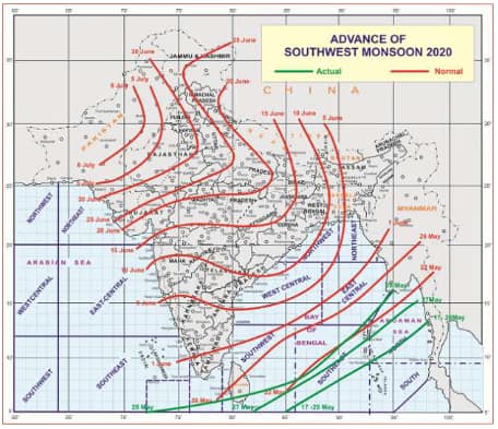
The southwest Monsoon advances further into some parts of Maldives-Comorin area, some more parts of south Bay of Bengal, remaining parts of Andaman Sea and Andaman and the Nicobar Islands, said the IMD.
New Delhi: A low-pressure area is likely to form over the southeast and adjoining east-central Arabian Sea from 31st May to 4th June. In view of this, conditions are very likely to become favourable from 1st June for the onset of Southwest Monsoon over Kerala, said a Ministry of Earth Sciences statement on Thursday (May 28)
The southwest Monsoon advances further into some parts of Maldives-Comorin area, some more parts of south Bay of Bengal, remaining parts of Andaman Sea and Andaman and the Nicobar Islands, said the India Meteorological Department.
The advance of Southwest Monsoon, according to the National Weather Forecasting Centre of the IMD:
With the strengthening of westerlies and increase in convective clouds, the Southwest Monsoon has further advanced into some parts of Maldives-Comorin area, some more parts of south Bay of Bengal, remaining parts of Andaman Sea and Andaman and the Nicobar Islands.
The Northern Limit of Monsoon (NLM) now passes through Lat.5°N/Long.72°E, Lat.6°N/Long.79°E, Lat.8°N/Long.86°E, Lat.11°N/Long.90°E, Lat.14°N/Long.93°E and Lat.16°N/Long.95°E.
During the next 5 days, conditions are becoming favourable for further advance of Southwest Monsoon into some more parts of the Maldives-Comorin area during the next 48 hours.
A low-pressure area is likely to form over the southeast and adjoining east-central Arabian Sea during 31st May to 4th June 2020. In view of this, conditions are very likely to become favourable from 1st June 2020 for the onset of Southwest Monsoon over Kerala, said the statement.
It further said that a low-pressure area has formed over the west-central Arabian Sea. It is very likely to concentrate on a Depression over the same region during the next 48 hours. It is very likely to move northwestwards towards south Oman & east Yemen coast during the next 3 days.
The IMD has also warned fishermen advising them not to venture into the west-central Arabian Sea from 29th May 2020 to 1st June 2020. The fishermen are also advised not to venture into the southeast and the east-central Arabian Sea from 31st May 2020 to 4th June 2020.
Meanwhile, the IMD has made key observations about weather conditions for the coming days:
1. Under the influence of a Western disturbance and an east-west trough in lower tropospheric levels, rain/thunderstorm accompanied with lightning, hail, and squall at isolated places very likely over Western Himalaya Region & adjoining plains during 28th-30th May 2020.
2. As a result, maximum temperatures over plains of north India and central and west India very likely to fall by 3-4°C during the next 3-4 days. Hence the prevailing heatwave conditions are very likely to occur at isolated pockets of northwest & central India on today and abate thereafter.
3. Heavy to very heavy rainfall at isolated places over Tripura and Mizoram during the next 24hours and Heavy rainfall over Assam and Meghalaya. Heavy rainfall at isolated places over parts of south peninsular India from 28th-31st May 2020 with isolated Heavy to Very Heavy Rainfall over Kerala and Lakshadweep during 30th-31st May 2020.
Stay informed on all the latest news, real-time breaking news updates, and follow all the important headlines in india news and world News on Zee News.
)

