

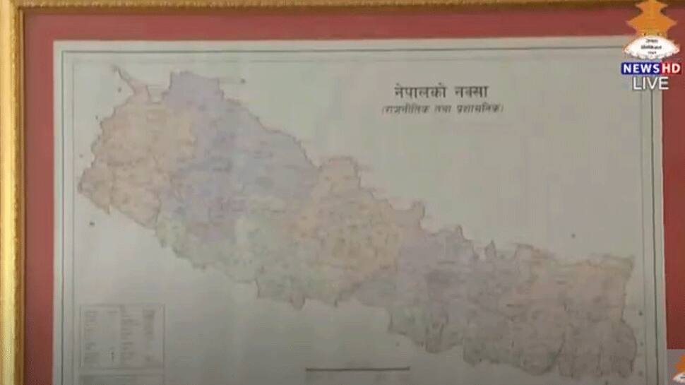
Nepal Parliament's lower house clears new map showing Indian territories of Lipulekh, Kalapani and Limpiyadhura as its own
The Lower House of Nepal's Parliament on Saturday unanimously voted to amend the Constitution to update the country's new political map, laying claim over the strategically key areas of Lipulekh, Kalapani and Limpiyadhura along the border with India.
Trending Photos

 8
8- 7
- 9
- 7


 "Nepal Parliament's lower house clears new map showing Indian territories of Lipulekh, Kalapani and Limpiyadhura as its own")
New Delhi/Kathmandu: The Lower House of Nepal's Parliament on Saturday (June 13, 2020) voted unanimously to amend the Constitution to redraw the country's new political map, laying claim over the strategically key areas of Lipulekh, Kalapani and Limpiyadhura along the border with India.
According to reports, leading Opposition parties, including Nepali Congress (NC), Rastriya Janata Party-Nepal (RJP-N) and Rastriya Prajatantra Party (RPP), voted in favour of the government bill to amend Schedule 3 of the Constitution to update the national emblem by incorporating the new controversial map.
A two-thirds majority was required in the 275-member House of Representatives or the lower house to pass the bill.
It may be noted that Nepal’s Parliament had on June 9 unanimously endorsed a proposal to consider the Constitution amendment bill to pave way for endorsing the new political map amid the border row with India.
Now, the bill will be sent to the National Assembly where it will undergo a similar process. The ruling Nepal Communist Party commands a two-third majority in the National Assembly. The NA will have to give lawmakers 72 hours to move amendments against the bill's provisions, if any.
After the National Assembly passes the bill, it will be submitted to the President for authentication, after which the bill will be incorporated in the Constitution.
The government on Wednesday formed a nine-member team of experts to collect historical facts and evidence related to the area.
Diplomats and experts, however, questioned the government's move, asking why the task force was formed when the map has already been released and approved by the Cabinet.
India, on the other hand, has been maintaining that these three areas belonged to it. "We have already made our position clear on these issues. India deeply values its civilisation, cultural and friendly relations with Nepal," Ministry of External Affairs (MEA) Anurag Srivastava had said on June 11.
The ties between the two countries came under severe strain after Defence Minister Rajnath Singh inaugurated the 80-KM-long road on May 8. Nepal reacted sharply to the inauguration of the road claiming that it passed through Nepalese territory. India rejected the claim asserting that the road lies completely within its territory.
In his comments on Thursday, Srivastava also spoke about how India has been reaching out to friendly neighbouring countries including Nepal in line with Prime Minister Narendra Modis initiative to chart out a common strategy to combat COVID-19 in the region.
Stay informed on all the latest news, real-time breaking news updates, and follow all the important headlines in india news and world News on Zee News.
Live Tv
 "DNA: Uproar over freebies in Delhi!")
 "DNA: AIMIM plans to field 2020 Delhi riots accused Shahrukh Pathan")
 "DNA: A report showing the reality of Bangladesh")
 "DNA: Power Theft Allegations Against SP MP Ziaur Rahman Barq")
 "DNA: Hot Tea Linked to Cancer Risk!")
 "DNA: Why Jordan Fears After Syria’s Coup?")
 "DNA: Gandhi Family Ruined My Career, says Mani Shankar Aiyar")
 "DNA: NSA Ajit Doval’s China Visit - Inside Story")
 "DNA: Ground Report- Tight Security Arrangements for Mahakumbh")
 "DNA: Who got superstar Allu Arjun arrested?")
